16.24.010 Intent and organization.
A. It is the intent of this chapter to:
1. Encourage density and a diverse mix of uses in the core area;
2. Create a core area that is strongly pedestrian-oriented and transit friendly;
3. Create a strong identity for the core area that supports the policies of the Downtown Comprehensive Plan, the Downtown 2000 Plan, and the Woodland District Strategic Plan;
4. Create places that provide for the needs of a diverse population;
5. Provide a comfortable pedestrian experience and commercial-retail opportunities;
6. Promote the development of an office hub within the Woodland District that supports the surrounding retail component; and
7. Promote high density residential in mixed-use patterns throughout the Woodland District.
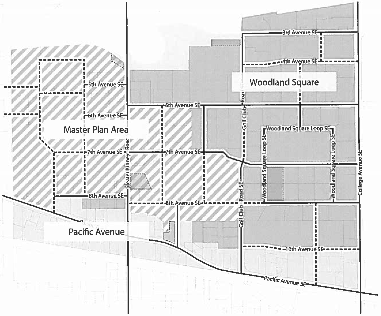
B. Woodland District Urban Neighborhoods Intent Statements. The Woodland District is divided into three subdistricts as shown in Figure 16.24.010-1:
1. Urban Neighborhood 1--Woodland Square. The goals for Urban Neighborhood 1 promote development that strives to combine commercial and housing uses on a single site or in close proximity. The form-based code (FBC) allows increased development on busier streets without fostering a strip commercial appearance. Development will support transit use and provide new housing opportunities in the city. The emphasis of the commercial uses is primarily on commercial, service, medical, educational, office, and locally-serving retail. Development is intended to consist primarily of businesses on the ground floor with services and/or housing on upper stories. Development is intended to be pedestrian-oriented with buildings close to and oriented to the sidewalk, especially at corners, with through block connections that provide access between properties, and a pedestrian-scale grid of streets.
2. Urban Neighborhood 2--Pacific Avenue. The goals for Urban Neighborhood 2 promote low- and medium-intensity development with a local or regional emphasis along Pacific Avenue SE. This subdistrict is intended to prevent the appearance of strip commercial development. Development is expected to balance the needs of pedestrians, bicycles, automobiles, and transit with a mixture of commercial, service, and residential uses. Although Pacific Avenue is the primary street for lots and parcels, infill blocks that have multiple frontages where the site (parcel) abuts the Woodland Trail development may use the trail as a ground level street-facing elevation of buildings and will take advantage of pedestrian connection to the trail. Development will balance the needs of autos, pedestrians, and transit users.
3. Urban Neighborhood 3--Master Plan Areas. The goals for Urban Neighborhood 3 promote development that strives to combine regional commercial-retail and housing uses on a single site or in close proximity. The development standards allow increased development on busier streets without fostering a strip commercial appearance. Development will support transit use and provide new housing opportunities in the city. The emphasis of the commercial uses is primarily on commercial, service, medical, educational, office, and local-serving and region-serving retail. Development is intended to consist primarily of businesses on the ground floor with services and/or housing on upper stories. Development is intended to be pedestrian-oriented with buildings close to and oriented to the sidewalk, especially at corners with through block connections that provide connections between properties and an overall modified grid of streets.
The Woodland District Master Plan requirements strive to achieve a finer-grained network of streets and paths than currently exists, while permitting property owners flexibility regarding location, alignment and design, or type of streets and paths. New streets and paths will be located within easements or rights-of-way, and new infill blocks will be created as a result. Once a new infill block is created, the FBC development standards will apply in the same way that they will apply to legally defined sites and street-bounded blocks within the rest of the Woodland District. FBC development standards include stormwater regulations, height limits, setbacks and frontage type requirements.
C. Regulating Plan.
1. Description of the Regulating Plan. The Regulating Plan translates the community vision into a map. The Regulating Plan designates the locations, subdistricts and streets that are intended to embody specific physical characteristics. It specifies the location and applicability of specific design treatments and maps where they are required. The Regulating Plan works in tandem with the development standards, tables and figures to define the shape, size and location of streets, through connections, infill blocks, buildings and landscaping.
The Regulating Plan for the Woodland District is set out in Figure 16.24.010-1, Regulating Plan, Subdistricts; Figure 16.24.050-1, Regulating Plan, Street Types; and Figure 16.24.060-1, Regulating Plan, Building Heights. The Regulating Plan specifies the subdistricts, street types and building heights that apply to each lot, parcel of land, or infill block.
The street type that applies to a specific street or section of a street is indicated by the color and corresponding name shown on the Table 16.24.050-2, Overview of Streets and Through Connection Types.
On Figure 16.24.050-1, Regulating Plan, Street Types, where the street type, as indicated by color, extends through an intersection, that street type shall be considered as the higher order street and shall apply to the intersection, and to the intersecting street until a distance of one hundred feet from the confluence of lot lines at the corner, or until the next lot line away from the corner, whichever distance is shorter.
Allowable building heights are shown on Figure 16.24.060-1, Regulating Plan, Building Heights.
D. Organization of This Chapter, Woodland District Hybrid Form-Based Code.
|
Sub Chapter |
Figures and Tables |
|---|---|
|
16.24.010, Intent and organization. |
Figure 16.24.010-1, Regulating Plan, Subdistricts |
|
16.24.020, Definitions. |
|
|
16.24.030, Uses. |
Table 16.24.030-1, Urban Neighborhoods |
|
16.24.040, General standards required for all development. |
Table 16.24.040-1, Master Plan Eligibility Summary |
|
Table 16.24.040-2, Improvement Responsibilities |
|
|
Table 16.24.040-3, District Wide Development Standards |
|
|
16.24.050, Streets, through connections and connection spacing. |
Figure 16.24.050-1, Regulating Plan, Street Types |
|
Table 16.24.050-1, Connections and Connection Spacing |
|
|
Table 16.24.050-2, Overview of Streets and Through Connection Types |
|
|
Figure 16.24.050-2, 6th Avenue |
|
|
Table 16.24.050-3, 6th Avenue |
|
|
Figure 16.24.050-3, 6th Avenue Sidewalk Improvements |
|
|
Table 16.24.050-4, 6th Avenue Sidewalk Improvements |
|
|
Figure 16.24.050-4, Golf Club Road |
|
|
Table 16.24.050-5, Golf Club Road |
|
|
Figure 16.24.050-5, Golf Club Road Sidewalk Improvements |
|
|
Table 16.24.050-6, Golf Club Road Sidewalk Improvements |
|
|
Figure 16.24.050-6, Pacific Avenue |
|
|
Table 16.24.050-7, Pacific Avenue |
|
|
Figure 16.24.050-7, Pacific Avenue Sidewalk Improvements |
|
|
Table 16.24.050-8, Pacific Avenue Sidewalk Improvements |
|
|
Figure 16.24.050-8, Through Connection, Minimum Requirements |
|
|
Figure 16.24.050-9, Through Connection, Optional Components |
|
|
Table 16.24.050-9, Through Block Connection, Minimum Requirements and Optional Components |
|
|
Figure 16.24.060-1, Regulating Plan, Building Heights |
|
|
Table 16.24.060-1, Building Form, Siting and Massing Standards |
|
|
Figure 16.24.060-2, Height Options for Small Footprint Buildings |
|
|
Table 16.24.060-2, Height Options for Small Footprint Buildings |
|
|
Table 16.24.060-3, Site Design and Landscape Standards |
|
|
Figure 16.24.070-1, Building and Landscaping Frontage Type 1--Linear |
|
|
Table 16.24.070-1, Building and Landscaping Frontage Type 1--Linear |
|
|
Figure 16.24.070-2, Building and Landscaping Frontage Type 2--Forecourt |
|
|
Table 16.24.070-2, Building and Landscaping Frontage Type 2--Forecourt |
|
|
Figure 16.24.070-3, Building and Landscaping Frontage Type 3--Porch-Stoop-Terrace |
|
|
Table 16.24.070-3, Building and Landscaping Frontage Type 3--Porch-Stoop-Terrace |
|
|
Figure 16.24.070-4, Building and Landscaping Frontage Type 4--Landscape Building |
|
|
Table 16.24.070-4, Building and Landscaping Frontage Type 4--Landscape Building |
|
|
Figure 16.24.070-5, Building and Landscaping Frontage Type 5--Low Wall and Trellis |
|
|
Table 16.24.070-5, Building and Landscaping Frontage Type 5--Low Wall and Trellis |
|
|
Figure 16.24.070-6, Building and Landscaping Frontage Type 6--Urban Fence or Wall |
|
|
Table 16.24.070-6, Building and Landscaping Frontage Type 6--Urban Fence or Wall |
|
|
Figure 16.24.070-7, Building and Landscaping Frontage Type 7--Landscape Setback |
|
|
Table 16.24.070-7, Building and Landscaping Frontage Type 7--Landscape Setback |
|
|
16.24.080, Design toolbox. |
Table 16.24.080-1, Low Impact Development Approaches |
|
Table 16.24.080-2, Street and Through Connection Crossing Approaches |
|
|
Table 16.24.080-3, Traffic Calming Approaches |
|
|
16.24.090, Form-based code review. |
|
|
16.24.100, Appeals. |
|
|
16.24.110, Amendment of an approved development application. |
|
|
16.24.120, Submittal requirements. |
|
|
16.24.130, Additional information for review. |
|
Figure 16.24.010-1. Regulating Plan, Subdistricts
(Ord. 1487 §3 (part), 2016).